
- Offer Profile
- Welcome to the Rutgers University Coastal Ocean Observation Lab! RU COOL! Our research focuses on the bio-physical processes of the coastal ocean. Our lab is constantly involved in research projects where operational observatories are used to collect real-time data for adaptive sampling. We study the coastal waters off New Jersey and around the World. We continue to collaborate with other research groups and commercial companies, developing new technologies for ocean sampling.
About RU COOL
- The Coastal Ocean Observation Lab is also known as the Marine Remote Sensing Lab. The Coastal Ocean Observation Lab (COOL) at Rutgers University is part of the Institute of Marine and Coastal Sciences. The lab was established in October 1992 by Dr. Scott M. Glenn. Funding for the creation of the Lab came from a grant by the Port Authority of New York/New Jersey.
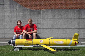
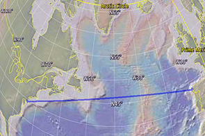
A robot crossing the Atlantic - Autonomous Underwater Vehicles (AUVs)
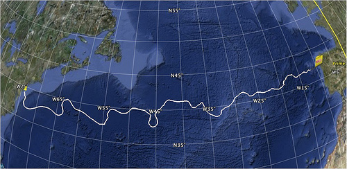
The Scarlet Knight's Trans-Atlantic Challenge - A robot's exploration of the unknown ocean
- On April 27, 2009, students and scientists from
Rutgers University launched a small underwater robotic glider off the coast
of New Jersey. The glider was christened The Scarlet Knight by Zdenka
Willis, director of the U.S. Integrated Ocean Observing System. While
previous explorers like Columbus and Lindbergh used boats or planes to cross
the Atlantic, The Scarlet Knight will attempt to be the first underwater
robot to cross the Atlantic Ocean. With help from a number of international
partners, students from the Coastal Ocean Observation Lab will pilot The
Scarlet Knight Glider on its eight-month voyage
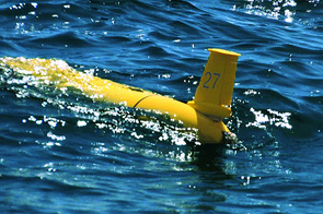
7 Fun Facts About RU27
- RU27 called home over 1000 times during the mission to report her location and send/receive data.
- RU27 moved her buoyancy pump approximately 22,000 times, which allowed her to…
- Complete approximately 22,000 inflections, 11,000 dives and 11,000 climbs.
- The raw data shows that Scarlet traveled vertically approximately 2200 kilometers (almost 1400 miles). Explanation: Glider goes more forward then up and down when it is flying.
- Almost 16 MB of data was transferred via satellite during the mission. This is likely low for a 220-day deployment but that is due to an energy/efficiency/surface risk habit.
- Scarlet compared to a car: A gallon of gas has approximately 131,940,000 J of energy; an efficient car can travel 30 miles on that gallon so approximately 4,398,000 J/mile. Scarlet, with currents, did 4598 miles burning 27,898,182 J having an average of about 6,067 J/mile. End result: Scarlet can cover 725 x more distance than a car with the same energy. She is a 21,700-mpg car equivalent (remember though car much bigger and goes faster!). A car could only travel 6.3 miles on the same amount of energy that Scarlet Knight used to cross the Atlantic.
- Scarlet compared to the Rockefeller Christmas tree: The Christmas tree at Rockefeller plaza used to use approximately 3,510 kilowatt hours / day meaning. Scarlet's energy used would last 3 minutes. However, in 2007 they switched to LED diodes meaning that one could now power the tree for about 8.1 minutes or send glider across the Atlantic ocean.
Autonomous Underwater Vehicles (AUVs) a.k.a. Gliders
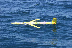
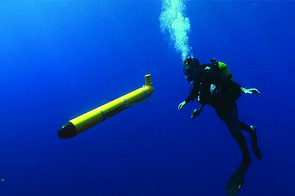
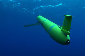
- The Slocum Coastal Electric Glider (Webb
Research Company, Falmouth, MA, Figure 1) is an autonomous underwater
vehicle that converts changes in vehicle buoyancy to vertical motion. A pair
of fixed wings provides forward momentum to move horizontally through the
ocean. While the majority of the glider is reserved for glider mechanics,
battery storage and communication equipment, a section is devoted
exclusively to scientific payload. A suite of miniaturized physical and
bio-optical instruments, which measure in situ water properties including
temperature, salinity, and the absorption and scattering of light in the
water column, have been and are currently under development for placement in
the glider’s science payload bay
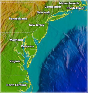
The Coastal Ocean Observation Lab at Rutgers University Institute of Marine & Coastal Sciences (IMCS) and Webb Research Corporation are currently focusing on the development and deployment of a fleet of gliders to continuously patrol the coastal oceans. The instruments, combined with the mobility and long-range communication capabilities of the glider, are providing continuous, near real time information on ocean physics and biology. Beginning in November 2003, a single glider has been deployed each month with the task of patrolling the New Jersey Shelf Observing Systems ENDURANCE LINE. The Endurance Line begins about ~5km southwest of the Rutgers University Marine Field Station and runs offshore to the continental shelf break, approximately 120km. Mission durations range from 2 – 4 weeks, depending on the instrument package, and have allowed the COOL lab to begin building a historical database on the physics and biology of the New Jersey Shelf.
In addition to the Endurance Line Project, we’ve undertaken a number of other concurrent glider deployments in areas including Martha’s Vineyard, MA, Virginia Beach, VA, the West Florida Shelf and Sandy Hook National Recreation Area in New Jersey. All glider communication is accomplished via Iridium Satellite phone link, allowing us to deploy gliders in remote locations while handling all data transfer and re-tasking from IMCS in New Brunswick, NJ.
The aim of this page is to provide the user with information on the glider vehicle, mechanics and instrumentation in addition to a data archive, which will allow the user to easily access current and archived data products provided by the gliders.
Building a Networked Ocean World
Mid-Atlantic Regional Coastal Ocean Observation System - MARCOOS
- MARCOOS is a joint effort with 30 Principal Investigators from 20 academic, governmental and private institutions across the region. MARCOOS is deploying and operating the Regional Coastal Ocean Observing System designed to fulfill user needs defined within the Mid-Atlantic Coastal Ocean Observing Regional Association (MACOORA). MACOORA is one of 11 Regional Associations in the US Integrated Ocean Observing System (IOOS).
Objectively Mapping Global Ocean Biomes
- The purpose of this three-year NASA funded effort to
objectively map and detect changes in large ocean ecosystems. We are using
algorithms developed in the field of bioinformatics. These large ocean
ecosystems are called biogeographic provinces. Biogeographic provinces
provide useful categories for comparing and contrasting important ocean
processes such as primary production, carbon flux, and species distribution
and diversity. Climatological provinces have been identified using a priori
expert knowledge. Discerning temporal trends and fine scale structures
require objective automatic methods. We use objective classification on
global remote sensing data to automatically produce time and space resolved
province distributions. Our results show seasonal patterns in province
geography reflect well known ocean processes. These province locations are
verified by independent in-situ data from Canada’s Federal Department of
Fisheries and Oceans, the Coriolis project for operational oceanography and
the National Oceanic and Atmospheric Administration Atlantic Oceanographic
and Meterological Laboratory.
Project Result- We have computed the mean state of the biome locations based on the entire MODIS-Aqua dataset. There are approximately 20 different types of biomes (depending on which time period is analyzed). Several of them show remarkable similarity to the biomes/provinces that Longhurst (1998) first described. However, because our analysis is not dependent on long-term climatological analysis to define the regions, we can examine the evolution of these provinces over time, as well as what the interactions are along the boundaries in high detail.
- We have verified our predicted locations of province boundaries with in-situ ship tracks and well known climate indices. We have verified boundary locations in the North Atlantic, the South Pacific, the Equatorial Upwelling Region, and the Mediterranean Sea. These five regions are hydrographically dissimilar, so we are confident that our approach will work world wide.
- We have made two time series of province distributions through time, one for MODIS-Aqua and one for a SeaWiFS/AVHRR combination. The MODIS-Aqua time series from Jan-2002 through Dec 2006 shows the seasonal evolution of these provinces over a five year period.
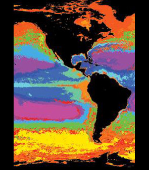
MODIS-Aqua
- An example of province distributions computed from an annual average of MODIS-Aqua. The different colors represent the different classes of biomes or ecosystems
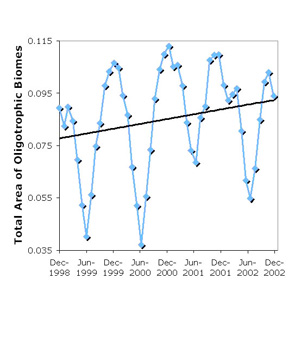
oligotrophic biomes
- Increase in the total area of oligotrophic biomes (purple areas in top figure) over a five year period. This shows both the seasonal and secular changes in province distribution in the global ocean.
Bio-Optical Models and Forecasting, DoD Expresso
- Rapid Environmental Assessment Using an Integrated
Coastal Ocean Observation Modeling System – Multidisciplinary University
Research Initiative (MURI)
Optical properties on the continental shelves are complex, representing variable contributions of phytoplankton, Colored Dissolved Organic Matter (CDOM), and non-algal particles. Over the past few years, the amount of optical data available via remote or in situ observations rapidly expanded. These observations have proven to be very effective at delineating hydrographic features not evident in the traditional physical data that are currently assimilated into numerical forecast models.
In this project, researches from Rutgers University, the Woods Hole Oceanographic Institution, Dalhousie University and the California Polytechnic State University are working together combining physical and optical observations with models to enhance our understanding of coastal processes.
The main goals of the project are:- To improve our capability of forecasting ocean color;
- To use ocean color observations to reveal features not easily seen on hydrographic fields and, therefore, improve physical models.
In order to accomplish these goals, we are currently working on:
- The development and improvement of data assimilation techniques, which includes the use of physical and optical data;
- The continuous expansion of our observational capabilities. That includes access to an international constellation of satellites (thermal images, ocean color and synthetic aperture radar), nested CODAR arrays providing hourly maps of surface velocities spanning the entire Middle Atlantic Bight, and a fleet of coastal AUVs (Gliders and REMUSs) capable of measuring in situ physical and optical properties;
- The use of coupled models to investigate the relation between the ocean physics and optics on the Middle Atlantic Bight.
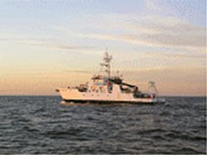
The R/V Hatteras sailing the ocean waves of NJ at sunset.
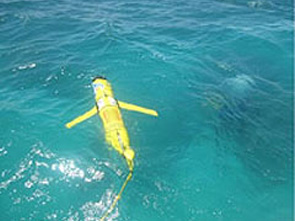
Rutgers University Glider soon after deployment
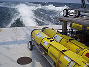
Gliders ready for deployment off New Jersey
North East Observing System - NEOS - Satellite Imagery
- We offer satellite data product to research, industry,
education and the general public. Satellite data are collected with SeaSpace
L-Band and X-Band satellite dishes, both of which are on the top of the
Institute of Marine and Coastal Sciences building on Cook Campus within the
New Brunswick Campus of Rutgers, The State University of New Jersey.
Our L-Band dish (left) was installed in the Fall of 1992 and collects AVHRR data from three of NOAA's POES satellites and China's FY1-D satellite.The X-Band dish (right) was installed in the Fall of 2003 and collects MODIS data from NASA's Aqua and Terra satellites, as well as ocean color data from India's Oceansat satellite.
Data are processed to into various products (i.e., sea surface temperature, ocean color, etc.) and then converted jpeg images are made for easy downloading and viewing. There are detailed product descriptions on each product page. Sea Surface Temperature is our largest image library, with imagery reaching back to 1993. Chlorophyll Concentration imagery goes back to 2001. Our other image archives begin in 2004.
Building the Future Ocean Cyberinfrastruture
- Network for Ocean Research, Interaction and
Application - NORIA
Oceanography is augmenting the ship-based expeditionary science of the last two centuries with a distributed, observatory-based approach in which scientists continuously interact with instruments, facilities, and other scientists to explore the earth-ocean-atmosphere system remotely. In order to provide the U.S. ocean sciences research community with access to the basic infrastructure required to make sustained, long-term and adaptive measurements in the oceans, the National Science Foundation (NSF) Ocean Sciences Division has initiated the Ocean Observatories Initiative (OOI).
Routine, long-term measurement of episodic oceanic processes on a wide range of spatial and temporal scales is crucial to resolving scientific questions related to Earth’s climate, geodynamics, and marine ecosystems. Innovative ocean observatories providing unprecedented levels of power and communication and access to real-time sensor networks will drive scientific innovation and provide education and outreach capabilities that will dramatically impact the general understanding of, and public attitude toward, the ocean sciences.
The OOI comprises three distributed yet interconnected observatories spanning global, regional and coastal scales that when the data is combined will provide will allow scientists study a range of high priority processes highlighted by the community. The OOI CyberInfrastructure (CI) constitutes the integrating element that links and binds the three types of marine observatories and associated sensors into a coherent system-of-systems.
The objective of the OOI CI is to provide a comprehensive federated system of observatories, laboratories, classrooms, and facilities that realizes the OOI mission. The infrastructure provided to research scientists through the OOI will include the sea floor cables combined with water column fixed and mobile systems. The CI initiative also includes components such as unified project management, data dissemination and archiving, and education and outreach activities essential to the long-term success of ocean observatory science. The vision of the OOI CI is to provide the OOI user, beginning at the science community, with a system that enables simple and direct use of OOI resources to accomplish their scientific objectives. This vision includes direct access to instrument data, control, and operational activities described above, and the opportunity to seamlessly collaborate with other scientists, institutions, projects, and disciplines.
Reaching Society and Future Generations - COSEE NOW
- Centers For Ocean Sciences Education Excellence -
Networked Ocean World
COSEE-NOW proposes to use information generated by ocean observing systems (OOS) as a powerful platform to enhance public literacy about the ocean and stimulate public support for ocean research.
The mission of COSEE-NOW is to enable use of transformative ocean research and effective education practices to inspire students and the general public in ocean exploration, discovery, and stewardship.
COSEE-NOW has identified three key areas of investment that combine the resources and experiences of the project PIs to promote high-quality OOS education and public outreach (EPO) and contribute to the COSEE network.
The goals include:- Assess the knowledge and needs of target OOS audiences: The PIs propose to survey target audiences including the K-16 students/teachers, policy/decision makers, and the science literate public to understand their awareness, knowledge, and attitudes related to OOS. The results of these needs assessments will enable COSEE-NOW and OOS EPO providers to develop useful products while increasing awareness of OOS and its relevance to these audiences.
- Improve collaboration and coordination among scientists and educators in the OOS community. This proposed effort will support EPO programs within existing OOS networks while helping to develop planned OOS initiatives. Our work will increase the effective translation and dissemination of scientific data and knowledge to broader audiences and improve use of effective education practices among scientists in the OOS community.
- Increase public awareness of Ocean Observing Systems. COSEE-NOW is externally focused on building public awareness of OOS through innovative media products, K-12 classroom applications, and free-choice learning environments. Through this goal, we expect to increase awareness of OOS and ocean literacy concepts among a variety of target audiences.
A thematic COSEE- Networked Ocean World (NOW) can be used as a vehicle to provide educational leadership as observatories continue to transition from vision to reality. This COSEE’s efforts will serve as the pathfinder for collaborative EPO activities associated with existing as well as new observatories, visualizations, and cyberinfrastructure technologies that will come online in the next five to ten years.
COSEE NOW will address identified OOS community needs including the development of a community of educator leaders, the creation of a coherent collection of education products, and the implementation of a strategy for delivering these products and messages to target user groups. In addition, we will provide the bridge linking the scientific and societal needs of ocean observatories while promoting teaching and learning, broadening the participation of underrepresented audiences, enhancing education infrastructure, and disseminating our results to educators and scientists alike.CORE Staff will ensure the Center’s goals are met and will convene the advisory committee and task forces. Project partners will manage specific Center tasks. In the future, additional project partners will be included, as the collaborative and cooperative nature of COSEE will help leverage funding in related areas.
COSEE-NOW, its partners, goals, and objectives, have been assembled and organized to meet needs that have been articulated by the OOS science and EPO communities as noted in this proposal’s letters of support. Our prior experience in the COSEE network, proven track record in OOS EPO, and our understanding of qualities for successful partnerships will serve us well as we pursue the tasks outlined in this proposal.
Success of the ocean networks will be measured by improved scientific understanding of the oceans and improved ocean literacy of human society. The proposed COSEE-NOW will build the scientist-educator partnerships necessary to create a networked ocean world.
International Consortium of Ocean Observing Labs
- The International Consortium of Ocean Observing Laboratories (I-COOL) is dedicated to the collaborative exploration of the ocean in order to improve our understanding of our planet, to build ocean technologies for next century and to excite the next generation of ocean scientists and engineers. I-COOL believes that collaboration between friends spanning the international community provides a powerful tool for groups to leverage and enable each others efforts. I-COOL was formed over a dinner with good wine one evening in Paris with scientists from Rutgers, Dalhousie University and California Polytechnic State University. The I-COOL group has now grown to encompass laboratories spanning the United States (Rutgers, California Polytechnic State University, Mote Marine Lab, University of Maryland, University of California at Santa Barbara), Canada (Dalhousie University, University of Victoria), Australia (James Cook University, University of Western Australia), Norway (Nansen Center, University of Bergen, University of Trondheim), France (Laboratoire d’Oceanographie de Villefranche), Spain (Puertos del Estados, Qualitas Remos), Germany (Leibniz-Institute for Baltic Sea Research), United Kingdom (Proudman Labs, National Oceanography Centre), and Ireland (National University of Ireland)
Homeland Security Center Of Excellence
- Prior to September 11, 2001, the Marine Transportation
System (MTS) and the business communities it supports focused on speed,
reliability and cost of operation. Security, when addressed, dealt primarily
with keeping cargo safe from theft. A myriad of terrorist threats and
vulnerabilities abound in the new world order. The new paradigm requires a
multi-tiered approach, in terms of new technology development, and in policy
at the local, State, Federal and international levels in order to address
the complexity and ambiguity of today’s global maritime security
environment. More than in any other transportation mode, this new security
paradigm must be integrated into the business operations of the MTS in order
to achieve both security and economic gains.
The National Center for Secure and Resilient Maritime Commerce and Coastal Environments (CSR) brings together a unique set of academic institutions from around the nation and public and private sector partners with diverse expertise and significant experience in developing new knowledge, technology products, models, tools, policies & procedures, and training related to global maritime security and coastal safety. These capabilities will be applied to:- improve the security of the MTS and coastal and offshore operations, leveraging security investments to also improve economic performance;
- improve emergency response to events in the maritime domain; and
- improve the resiliency of the MTS, offshore operations, and coastal environments.
Long Duration Exploration - Building a Global Robotic Network
- Developing integrated smart observatory networks
“I walk into our control room, with its panoply of views of the sea. There are the updated global pictures from the remote sensors on satellites, there the evolving maps of subsurface variables, there the charts that show the position and status of all our Slocum scientific platforms, and I am satisfied that we are looking at the ocean more intensely and more deeply than anyone anywhere else.” Henry Stommel (1989)
Exploring the global ocean has been a fundamental factor driving human society. Historically humans have relied on ships to provide platforms to live, travel and explore the oceans for centuries. After ships, the next great technical evolution in ocean exploration was the development of satellite remote sensing. This revolution in the 1970’s provided a synoptic global perspective that has fundamentally altered our view of the world’s surface ocean. The advent of ocean robots in the last decade have ushered in the next technical revolution in oceanography. The robots provide a large subsurface picture of the ocean. We in the Coastal Ocean Observation Lab are committed to moving the robot revolution forward.
In Lithuania in 2006, Dr. Rick Spinrad from NOAA sat us down. He looked at us and began the conversation with, “For the good of your country, you must inspire the next generation of scientists and engineers and I want you to cross an ocean basin with a robot.” That was daunting… Since then in collaboration with Webb Research, we have focused on Dr. Sprinrad’s challenges. We believe that developing a permanent presence in the ocean using robots is a powerful tool to inspiring the next generation of the scientists and engineers. Therefore we wish to develop long duration flights and to have these missions conducted by young scientists during their undergraduate years. We believe this will be critical showing young people that science, engineering and exploration is the most rewarding career possible. 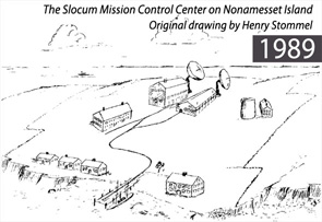
1989
- The Slocum Mission Control Center on Nonamesset Island - Original idea and drawing by Henry Stommel
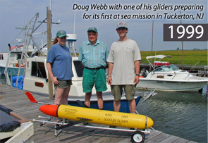
1999
- Doug Webb with one of his gliders preparing for its first at sea mission in Tuckerton, NJ
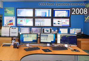
2008
- COOLRoom Operational Center today
Exploring a Changing World Ocean
Climate Change along the West Antarctic Peninsula, Pal-LTER
- As the world warms, ecosystems are changing.
Understanding the ecological consequences is critical as the magnitude and
pace of the predicted warming will produce novel climate conditions that do
not exist in the contemporary world. Even moderate warming scenarios predict
major extinctions. The Western Antarctic Peninsula (WAP) is undergoing the
most dramatic climate change on Earth (Fig. 1 and Fig. 2). The WAP region
has experienced a significant winter warming during the past half century
(5.4 times the global average). This warming has shortened the sea ice
season and perennial sea ice is gone. The maritime system of the northern
WAP is expanding southward, displacing the continental, polar system of the
southern WAP while 87% of the glaciers are in retreat. Associated with this
warming has been a climate induced migration in the WAP ecosystem spanning
the primary, secondary, and higher trophic levels (Fig. 3). We do not
understand the drivers of the temperature changes or the resulting ecosystem
changes, but we know the decline of ice is driving one of the largest and
most rapid climate induced shifts in a marine ecosystem on Earth (Fig. 1).
The Palmer LTER is dedicated to study the processes underlying these changes
and its impact on the ecosystem.
The Palmer LTER is now building on its previous research, with an emphasis on process studies and modeling to elucidate the mechanistic links between teleconnections, climate change, physical oceanographic forcing and ecosystem dynamics. To guide our research, we hypothesize that regional warming and sea ice decline associated with historical and on-going climate migration in the northern part of our study area have altered key ecological relationships, leading to changes in species distributions, increasing trophic mismatches and changes in habitat, food availability, ecosystem dynamics and biogeochemical cycling (Fig. 4). We will conduct targeted process studies linked to numerical model simulations. We will also test the hypothesis that deep cross-shelf canyons characterizing our core study region (200x600 km) are focal areas for ecosystem processes that result in predictable, elevated food resources for top-predators such as penguins, influencing their foraging ecology and distribution of breeding and wintering populations (Fig. 5). 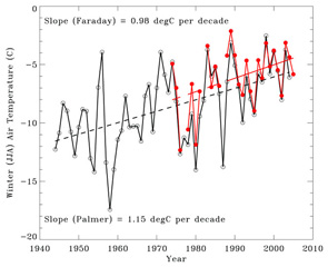
Fig 1. Mean Winter Temperatures
- Black British Faraday and Ukraine Vernadsky Station. Red is United States Palmer Station. The decadal warming trend along the West Antarctic Peninsula. The trend shows a dramatic warming over the last 70 years that represents Earth’s most rapid documented winter warming.
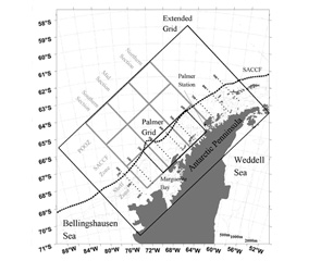
Fig 2. The Antarctic study area of the LTER.
- The grid is occupied by annual cruises and gliders. These efforts are complemented with studies at Palmer station (red circle).
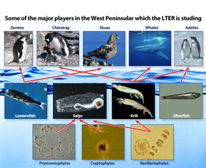
Fig 3. Some of the major players in the West Peninsular which the LTER is studying
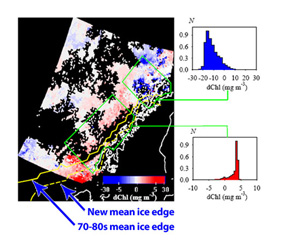
Fig. 4 Using several ocean color satellites
- decadal changes in the primary productivity have been observed. Chlorophyll has increased in the south and it has decreased in the northern waters
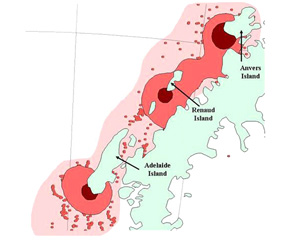
Fig. 5 The summer foraging areas for Adelie penguins
Dynamics of Dust and Phytoplankton in the Mediterranean
- Using Gliders to Resolve Dynamics of Dust and
Phytoplankton in the Mediterranean
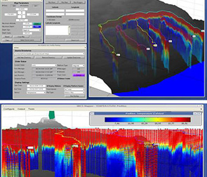
Optical properties are complex representing variable contributions of phytoplankton, Colored Dissolved Organic Matter (CDOM), marine and atmospherically derived non-algal particles. The relative contributions of these are particularly complex for enclosed inland seas such as the Mediterranean. It is critical to collect regional ocean color data from satellites which must be complemented with spatial subsurface measurements. The development of autonomous platforms outfitted with a range of physical/optical sensor packages offer great potential. Slocum Coastal Gliders make an ideal platform when coupled with the appropriate optical sensor suite. The utility of the Glider has lead to the development of Glider Operations Center (GOC) which allows operators anywhere in the world to remotely control and visualize Glider data which can also be easily merged with numerical model data outputs and/or remote sensing imagery.
Glider data will address the importance of atmospheric dust in the Mediterranean. The importance of atmospherically derived nutrients has been shown and its role to marine ecology and productivity has been frequently hypothesized. For example, in the Mediterranean, dust from the Sahara and northern European countries is hypothesized to account for up 15% of the new production and up to 14% of the total primary production in the Mediterranean; however documenting deposition and its relationship to primary productivity over the time (weeks to months) and space (100-1000 of kilometers) scales that these processes operate has been difficult. This has forced workers to rely on remote sensing; however these approaches are susceptible to the presence of dust which mimics the presence of phytoplankton in the satellite imagery. Ocean color algorithms use remote-sensing reflectance to estimate the concentration of chlorophyll a. In very clear waters the presence of dust can impact the accuracy of the empirical algorithms. Given this, is the ocean signal associated with atmospheric dust related to the stimulated phytoplankton productivity or is it simply the dust itself? We must quantify the impact of dust on both the in situ optical properties and biological communities over relevant spatial (100 kms) and temporal (month) scales in oligotrophic waters.
Given these interests we will in this project:- use a fleet of Webb Gliders to provide a regional subsurface physical and optical dataset to support ship-based NASA, NATO, and ONR efforts being conducted in the Mediterranean in autumn 2008 and spring 2009,
- coordinate the activities of a fleet Gliders outfitted with a variety of sensors to quantify the physical hydrography of the coastal and offshore waters in the Mediterranean,
- demonstrate a web-based GOC for Gliders with fleet control being transferred between operators on the ship, personnel at the NATO facility at La Spenzia, and scientists & students in United States throughout the month long experiment and,
- use data to understand physical and optical dynamics in the Mediterranean with a focus being on understanding the relative importance of atmospherically derived sub-micron dust particles and phytoplankton to determining the derived satellite data products.
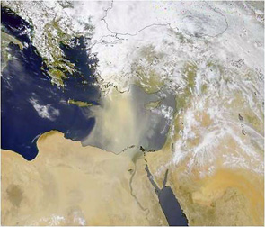
SeaWiFS
- A SeaWiFS visible image capturing Saharan dust transported to the Mediterranean. The dust appears as the brown haze over the Mediterranean.
GOC visualizer
-
Visualizations from the Glider GOC, providing a real-time command control
combined with advanced visualization capabilities.
A merged SST satellite, CODAR, and MURI sponsored Glider line. Capabilities also now exist to merge model outputs.
GOC visualizer
- Fleets of Glider data visualized in the GOC visualizer.
Polar Ice Caps and the Norwegian Partnerships
-
Technology for marine monitoring and ocean observation in Arctic
This international partnership is focused on developing the technologies to document and understand how changes in coastal waters impact the living resources and ecology of the Norwegian coast and Southwestern Barents Sea. Polar ecosystems have been experiencing dramatic changes over the last century. Warming air temperatures are thawing perma-frost, increasing river discharge, and thinning arctic ice. It is difficult to account for these changes through natural variability, and human activity has been implicated; however the role of both low frequency basin scale cycles and episodic events remains an open question. Additionally, ship traffic has increased and the production and shipping of oil and gas is expanding in the sub-arctic. The Barents Sea is also exposed to pollution from large rivers (Ob, Lena and the Yenisey) and Russian military installations which have been a source of nuclear waste. All these represent complex international issues that effect coastal waters, spanning multiple temporal and spatial scales and requiring the collection of relevant spatial time series data
The challenge of collecting continuous time-series data in oceans is formidable as only the surface is accessible with space-based remote sensing or shore-based radars. Physical hydrography and biogeochemical parameters are highly variable and coupled over a wide range of spatial and temporal scales (meters to thousands of kilometers, hours to decades) that cannot be adequately sampled using traditional sampling methods. This will require the development of sub-surface robotic networks. Time-series observations are needed to resolve both the mean and variance of parameters associated with episodic events, as well as those that occur on seasonal, annual, and interdecadal scales. This partnership in the coming decade will lay the foundation for developing a comprehensive understanding of biogeochemical cycles and temporal trends that will enable the development, parameterization, initialization and validation of global coastal biogeochemical models. The goal is develop a joint undergraduate program where the international cadre of students become the implementation team for deploying cutting edge new robotic networks to study the potential climate responses in the Antarctic.The proposed international collaboration focused on impact of the Norwegian coastal current (NCC) on the southern Barents Sea physical oceanography and biogeochemistry. The grey lines indicate the major currents. The dotted black line shows mean climatological winter sea ice extent. The solid red lines indicate cross-shore surveys that will be conducted monthly using a combination of AUVs. The broken red lines indicate the along shore Langragian surveys (each survey is designated by the arrow) to be conducted during spring or summer process studies. The solid blue lines indicate the existing and funded shore-based surface Norwegian surface current radar nests.
Mesoscale Processes and Microbial Activity in the Mona Passage
- Waters of the Mona Passage separate the islands of
Puerto Rico and Hispaniola and are under the influence of various mesoscale
phenomena including internal wave generation, eddy passage and the spreading
of buoyant river plumes. These processes are believed to closely modulate
microbial processes in the water column and the optical character of
near-surface waters. The UPRM and Rutgers research groups are involved in
several projects sponsored by ONR, NOAA and the Department of Energy with
the goals of characterizing optical and microbial modulation by internal
waves and tropical river plumes. Recently, the scientific groups began a
collaboration using autonomous underwater vehicles operated by the Rutgers
Coastal Ocean Observing Laboratory (COOL) to assay microbial activity and
dynamics in an effort to better understand carbon flux in tropical marine
environments. In October of 2007, an expedition aboard the Oceanic Research
Vessel, BOLD was initiated to monitor river plume dispersion and its
modulation by internal waves using COOL’s fleet of autonomous underwater
vehicles (gliders).
This UPRM/Rutgers experiment provided an opportunity to jumpstart collaborations between MACOORA and CaRA. Targeted interactions included the first autonomous underwater glider deployment in the Caribbean, initial site surveys for the CaRA HF Radar network starting on the west coast of Puerto Rico, a high interest region for homeland security purposes, plans for the CaRA Operations Center, and discussions of lessons learned from the MACOORA experience of setting up a Regional Association. During the visit by MACOORA leadership, Glider RU16 was deployed during a short boat trip off the UPRM field station at Magueyes Island near La Pagara. RU16 circled around the southwest corner of Puerto Rico and turned north into the Mona Passage between Puerto Rico and the Dominican Republic, transmitting temperature, salinity and optical data to shore through the Coastal Ocean Observation Lab at Rutgers University. Real-time data displays were used to plan shipboard operations during the R/V Bold cruise and to obtain discrete adaptive samples. The glider’s success demonstrated the ability to document:- The vertical and horizontal displacement of the tidally- generated internal wave known to occur at the site locally known as “El Pichincho”.
- Establish the optical and microbial modulation brought about by the internal wave.
- Visualize the impingement of the wave on the shelf edge at Mona Island.
Finally, this ability to obtain real time data from gliders was paramount for the adaptive sampling requirements of 21st century studies in ocean dynamics and biology.
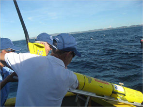
Fig. 1 First CaRA Glider Deployment Lajas, Puerto Rico - October 19, 2007.
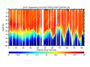
Fig. 2 Initial data from glider RU 16 demonstrating internal waves and impact on chlA levels.
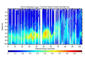
Fig. 2
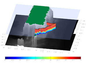
Fig 3. Temperature profiles along the southern coast of Puerto Rico from RU 16
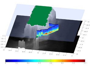
Fig 4. Chlorphyll profiles along the southern coast of Puerto Rico from RU 16
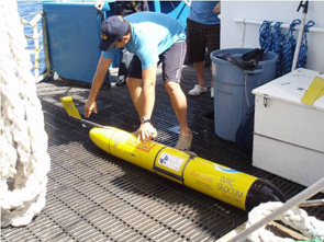
Fig 5. Glider recovery
Observations of the Structure and Dynamics of Mid-Shelf Fronts
- Improving our understanding of mid-shelf fronts will
contribute to the broader scientific thrust of determining the role of the
coastal ocean in the carbon cycle. The question of how the fronts impact the
cross-shelf flux of material is directly relevant to estimating the fate of
carbon delivered to the coastal ocean by rivers. It is also of interest to
researchers studying larval and juvenile fish, as it likely impacts
recruitment of organisms with widely separated spawning and nursery areas
(such as bluefish).
A frontal region at mid-shelf off the U.S. east coast has recently been identified in satellite sea surface temperature (SST) imagery (Ullman and Cornillon, 1999). It extends at least from the Scotian Shelf to Cape Hatteras at roughly the location of the 50 m isobath. The SST signature of these mid-shelf fronts (MSFs) is seen primarily in winter, and while weaker than the shelfbreak front, the MSFs are quite persistent.
The project objectives are to:- describe the vertical structure of the Mid Shelf Front of the New York Bight and its temporal variability and how it responds to forcing by surface wind and heat flux.
- to determine whether either of two competing theories for the formation of the midshelf front, the TD mechanism of Ou et al. (2003) and the BBL mechanism of Chapman and Lentz (1994), adequately accounts for the observations.
- determine the degree to which the front inhibits cross-shelf exchange of water properties.
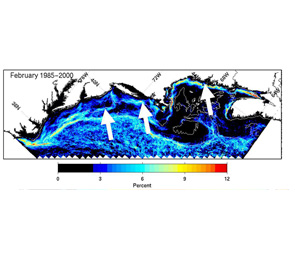
Fig. 1 Pixel-based probability of detection of SST fronts averaged over the month of February for the years 1985-2000.
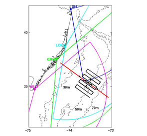
Fig. 2 Map of the proposed study area.
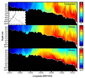
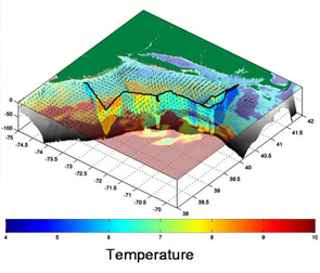
Fig 3. Hydrographic section across the mid shelf front off New Jersey made with a Slocum glider
Developing new technologies
Listening to Photosynthesis with Photoacoustics
- Of the solar energy impinging on the Ocean, or any
other water body, only small amount is available to the plankton, despite
this, the absorption of light drives photosynthesis and produces about half
of the oxygen on Earth. Developing new methods is a central problem for
biological oceanographers and biogeochemists. Photoacoustics is potentially
a new approach to study photosynthesis. It is an approach based on measuring
the changes in the temperature structure of water due to the heat released
from cells associated with the radiation decay of photosynthetic scales.
Current estimates are that close to 80% of the absorbed energy. This project
is to develop and assess the photoacoustic techniques to probe
photosynthesis and cellular physiology. The specific efforts on this project
is focused on:
The objective of the proposed study is to describe how light energy that is harvested by the photosynthetic apparatus is used. By doing this we will attempt to calculate an energy budget by quantifying the dissipation of absorbed light as heat and fluorescence, and its partitioning between the two photosystems.
We will combining photoacoustical, fluorescence and oxygen electrode detectors in the same measuring cuvette, and using pulsed laser flashes and alternating series of such flashes with and without a continuous saturating background light, we shall quantify the total energy absorbed by the photosynthetic apparatus and its stepwise dissipation as thermally generated acoustic signals, fluorescence and finally evolved oxygen. We shall also determine how light intensity affects the different energy flow and distribution patterns. 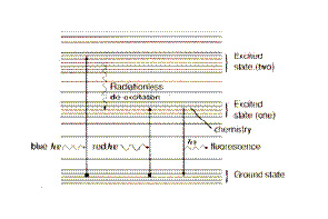
The pathways of energy dissipation within photosynthetic cells.
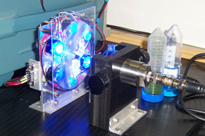
The photoacoustic cell developed by this program funded by the BiNational Science Foundation.
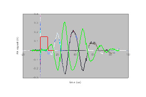
The photoacoustic signal measured using our photoacoustic cell. The black line is for a reference cuvette filled with black ink. The green line is for a culture of Synechococcus. Red line is the optical signal initiating the thermal wave associated with the cell.
Using Fluorescence Induction to Study Phytoplankton
- Measuring the health of phytoplankton using Webb
gliders
The ability to map the concentration and productivity of phytoplankton is a key to understanding the biogeochemistry of Earth. While great progress has been made to in mapping the concentration of the phytoplankton using ocean color techniques, the ability to measure rate processes remains difficult. Our group has been developing new platforms (cables & robots) for exploring the world’s oceans. As these technologies represent the future of ocean exploration and new sensors must be developed for these platforms. The buoyancy driven gliders represent the most challenging platforms as these systems require small sensors that have minimal power requirements. Therefore the goal of this project is to develop a new sensor that can measure the health of the phytoplankton with a sensor capable of being carried on a Webb Slocum glider. Over the last decade, chlorophyll fluorescence measurements have provided unprecedented insights into the factors controlling phytoplankton physiology and primary production in the ocean. The technique relies on active stimulation and detection of the induction and subsequent relaxation of chlorophyll fluorescence yields on micro- and millisecond time scales. Analysis of the induced variable fluorescence provides a comprehensive suite of fluorescent and photosynthetic parameters of the phytoplankton. From these, a detailed picture of photosynthetic status can be deduced. The measured parameters provide the basis to model gross primary productivity and assess the impact of environmental stresses. This project will build a miniature Fluorescence Induction and Relaxation (FIRe) System for Webb Gliders. This project will demonstrate the FIRe mounted on a Webb Glider.
Our results to date:- The prototype FIRe have been constructed. It will be mounted into a Glider. The initial deployment is currently scheduled for August 2008.
- To improve Glider power capabilities, a new lithium payload was developed and tested by flying a glider from New Jersey to Halifax Canada. The blog of the deployment can be found at http://blog.i-cool.org/.
- The prototype FIRe will be used to study the physiology of phytoplankton during the Fall and Winter in the Mid-Atlantic Bight. The goal will be to assess the impact of large storms on the health of phytoplankton.
FIRe measurement protocol
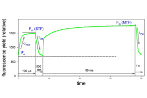
- An example of the FIRe measurement protocol consisting of four phases: 1. a strong short pulse of 100 µs duration (called Single Turnover Flash, STF) is applied to cumulatively saturate PSII and measure the fluorescence induction from Fo to Fm(STF); 2. weak modulated light is applied to record the relaxation kinetics of fluorescence yield on the time scale of 500 ms; 3. a strong long pulse of 50 ms duration (called Multiple Turnover Flash, MTF) is applied to saturate PSII and the PQ pool; 4. weak modulated light is applied to record the kinetics of the PQ pool re-oxidation the time scale of 1s
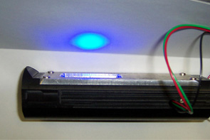
The prototype FIRe system for the Glider. Visible is the blue excitation light.
The flight path of the lithium Webb Glider.
Developing integrated smart observatory networks
- Global climate change and security and their effect on
economies, food supplies, energy use, security and our increasingly
populated coasts, is the most significant issue our children and theirs will
deal with during their lifetimes. Recent years have seen significant
strategic initiatives aimed at realizing national and global cyber
infrastructures, which will enable seamless, secure, on-demand access to,
and aggregation of, geographically distributed computing, communication and
information resources. However, while the infrastructure is being built, its
success will rely on dynamic computational methods that will integrate
computers, networks, data archives, instruments, observatories, experiments,
and embedded sensors and actuators. This will result in a new dynamic
data-driven approach (DDDAS) paradigm for monitoring, understanding and
managing natural systems – one that is information/data-driven and that
symbiotically and opportunistically combines computations, experiments,
observations, and real-time information to model, manage, control, adapt,
and optimize. Such a pervasive DDDAS infrastructure will promise to lead to
a new generation of oceanographic research and applications such as
- safe and efficient navigation and marine operations,
- efficient oil and hazardous material spill trajectory prediction and clean up,
- monitoring, predicting and mitigating coastal hazards,
- military operations,
- search and rescue, and
- prediction of harmful algal blooms, hypoxic conditions, and other ecosystem or water quality phenomena.
The goal of this research is to develop new infrastructure, theories, algorithms, engineering solutions and cross-disciplinary curricula to future challenging problems in oceanography. The specific goals include:
- To develop, deploy and evaluate a prototype pervasive dynamic oceanographic ecosystem that integrates sensors, networks, observatories, and computational algorithms to enable dynamic data driven research in oceanography and in particular the study of anoxia and hypoxia off the coast of New Jersey.
- To develop cross-disciplinary research curricula to provide students with the skills needed by the rapidly expanding network of research and applied observatories being constructed.
Acoustic mapping of fish schools
- More than 50% of fish species are known to be
gregarious at some point in their life-cycle, forming shoals (groups that
remain together for social reasons) or schools (synchronized and polarized
swimming groups). These groups are thought primarily to serve an
anti-predator function by allowing fish to avoid predators. Shoaling may
also enhance foraging by allowing fish to locate patchy food faster,
reducing time needed for predator vigilance. Another consequence of fish
aggregation is a change in strategy for predators relying on these fish.
Understanding of fish aggregation is critical for making accurate stock assessments as well as understanding the stability of these fisheries. Aggregations of fish affect their measurable acoustic properties. Individual fish cannot be detected, making assessment of the target strength, or ‘acoustic size’, difficult. Without knowledge of the target characteristics of the individuals in the school, assessment of numerical density and fish abundance using acoustic techniques is not possible. However, school characteristics can lead to acoustically distinguishable properties not available from individual fish. Experiments designed to look for geological sources of acoustic clutter have instead found that shoals or schools of fish are the dominant source of clutter in the Mid-Atlantic Bight. This has direct applied implications for applied Naval sonars.
Given this, this project is focused on:- Develop new acoustic techniques to measure aggregations of fish taking advantage of high frequency multibeam sonar from AUVs and compare to mid-frequency multibeam sonar,
- Relate mid-frequency acoustic bistatic and back scattering to high-frequency multibeam and split-beam backscatter and both to fish activity
- Relate fish causing acoustic scattering to physical and biological oceanography
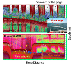
120KHz Echosounder
- 120KHz Echosounder transect in the Mid-Atlantic Bight illustrating the physical (sea floor, pycnoclines, frontal boundaries) and biological (fish and human ships) acoustic clutter that will be characterized by this proposed program.
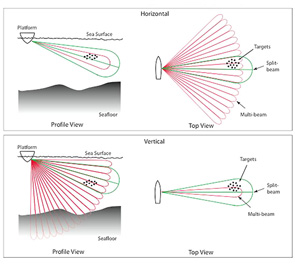
collacated splitbeam and multibeam sonar
- Illustrations of potential horizontal and vertical orientation of collacated splitbeam and multibeam sonar for water column scattering. The beam patterns and dimensions are not to scale.
Using CODAR to Map Waves and Rip Currents
- Development of an HF radar derived near-shore wave and
current product: Application to rip current probability along the New Jersey
coast.
Background: Rip Current Circulation
Rip currents are the number one cause of ocean drowning and rescue incidents along the coasts of the United States. According to the United States Lifesaving Association (USLA), 71% of the total surf zone rescues, 12,137 incidents, in 2003 were due to rip currents. Rip currents are strong near-shore features with cross-shore velocities on the order of 1 m/s and along-shore scales of tens of meters. Mechanisms for rip formation include wave-bottom boundary interaction, wave-wave interaction, and wave-current interaction (Dalrymple, 1975; Dalrymple, 1978; Sonu, 1972). Longshore currents are driven by a radiation stress generated by wave breaking. The theory is well developed. Less well developed is the theory for cross-shelf currents in the surface zone, rip currents. The approach in California is to use hf radar currents as the outer boundary to drive inner Shelf models. Wave height, period, and direction are a second input required at the boundary. Increased wave and current observations nearshore will help researchers to better understand the conditions favorable for rip current formation, and ultimately provide the necessary boundary conditions to predict rip currents.
Project goals and objectives- The primary goal of this project is to enhance existing remote sensing measurement techniques to provide a real-time continuous measure of near shore waves and currents. These data would benefit research focusing on near-shore wave/current interaction and could be incorporated directly into existing National Weather Service surf zone forecasts. To date total surface current data has required overlap from at least two sites, restricting coverage from the nearshore. Likewise, shallow water has limited wave observations particularly for the lower frequency systems. To do this we propose a 2 year project that will develop and evaluate an enhanced near shore wave and current product within the existing HF radar test-bed operated by Rutgers University on Sandy Hook, NJ.
- Algorithm enhancements (currents and waves): While HF radar current
and wave data has been provided to multiple users including the NWS WFO
in Mount Holly NJ, these data have been exclusively for products
assuming deep water dispersion and no wave refraction. As the water
depth or operating frequency decreases, bathymetric effects become more
important. For these cases, full wave dispersion and refraction must be
integrated into the wave and current estimates. When waves move into
shallow water, they are refracted and their dispersion relation changes.
Both the first and second order regions of the backscattered signal feel
the impact. Therefore the wave and current estimates must be corrected
for the shallow water.
Evaluate the HF radar derived near-shore wave and current observations at Sandy Hook testbed. The Sandy Hook site offers an excellent test bed for wave and current product development and evaluation. The standard, medium, and long-range systems each continuously sample the ocean currents and waves over scales of 1 km, 3 km and 6 km respectively. All three sites deployed at Sandy Hook represent the vast majority of HF radar systems deployed around the world. Products developed here can be transitioned to other systems along the New Jersey coast, and around the world.
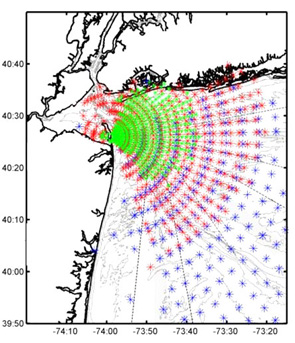
Fig 1. Nested coverage of the 25 MHz (green), 13 MHz (red), and 5 MHz (blue)
- CODAR system presently operating on Sandy Hook.
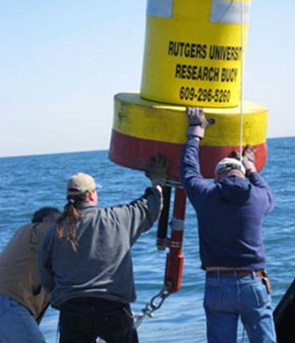
Fig 2. Mooring deployment for in situ comparisons with CODAR currents and waves.
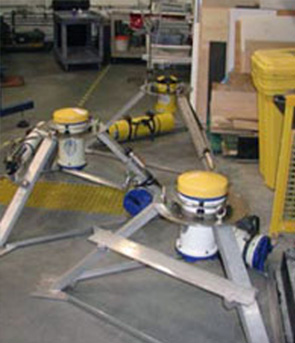
Fig 2. Mooring deployment for in situ comparisons with CODAR currents and waves.
Building robotic Darwin clusters for studying Southern ocean climate change
- From Microbes to Mammals: A Robotic Network to Study
Climate Induced Changes in an Antarctic Marine Ecosystem
The Western Antarctic Peninsula (WAP) is undergoing some of the most dramatic climate changes on Earth. The WAP region has experienced a winter warming trend during the past half century that is ~5.4 times the global average. Understanding these changes is extremely difficult to unravel and the unprecedented changes we are observing might be a harbinger of the potential changes in the future oceans.
As ocean ecosystems are changing and developing the capacity to resolve those changes and understand the implications for humanity is a clarion call for oceanography. Traditional modes of sampling will not suffice and efforts must be focused on developing networks capable of operating in a harsh environment and maintaining themselves for sustained periods at sea. The proposed robotic network will provide the critical advance needed by the community. We also emphasize that the proposed network is modular and could be relocated to any coastal shelf and scaled up to basin scales.
We will combine physical/biogeochemical robotic sampling to enable ship-based adaptive sampling over ecologically relevant spatial scales. The robotic network will also provide ecosystem data when ships are not available. We call this flexible and smart network a Darwin cluster. Over the relevant scales, the Darwin cluster will provide a long-term in situ network of sensors and instruments that operates in a manner similar to an insect hive with a distributed network of “worker” robots, all of which have specific capabilities that collectively and cooperatively serve the specified needs of a centralized, shore-based “brain.”
The data collected will provide critical spatial data for numerical ecosystem modeling. We propose to use the robots to study the dynamical interaction between the atmospheric forcing, physical mixing and phytoplankton concentration, metabolism and diversity. These data will be combined with active and passive acoustic sampling of higher trophic levels. This robotic network will be flexible in its sampling strategies in order to adjust on the fly as the ecosystem evolves in response to the physical forcing of the ocean. Initial priority will be given to ‘biological hotspots” along the Antarctic peninsula which are key areas for biogeochemistry, phytoplankton productivity, and higher trophic level feeding (zooplankton, penguins, whales, seals). The robotic networks data will also allow for adaptive sampling when ships are in the vicinity. This effort will directly leverage off an NSF sponsored Long Term Ecological Research (LTER) program being conducted along the WAP. 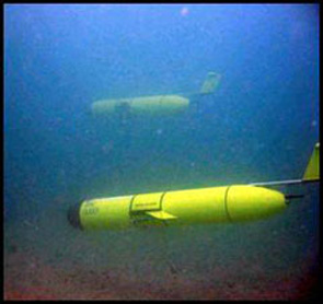
Rutgers gliders
- Two Rutgers gliders patrolling coastal waters. This project will result in the construction of a Darwin cluster to study climate change along the West Antarctic Peninsula.